Poster №4 – The geological structure of the island
 @kizhi
The process of the ground surface formation began millions of years ago. It is difficult to imagine global catastrophes, which caused fissures and various deformations in rocks. Volcanic activity resulted in filling underground cavities by lava which leaked through to the surface. Some traces of these catastrophes are evident now.
More recent events in geological history of the Earth were several glaciations. They were global catastrophes accompanied by critical changes in the atmosphere and biosphere. The ocean level went dozens of meters down, and the climatic zones were displaced. Glacier up to 3 km thick destroyed rocks and moved hundreds of billions of debris. Glaciers moved 1,000 m per year. A huge mass of ice depressed the crust resulting in tectonic movements.
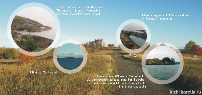
The last Ice Age ended about 9,000 years ago. The ice waned slowly (200 meters a year). Zaonezhie peninsula was freed of ice 11 thousand years ago. The glacier formed the present relief – undulation land, stone ridges stretching from northwest to southeast, smoothed cliffs (“ram’s back rocks”) and numerous boulders.
While the glacier moved, its bottom layer was enriched with debris, gravel and sand which were driven for considerable distances. But once this huge mass detached and stopped. This is a moraine. It could be 10 meters thick. Numerous small islands situated east of Kizhi are of morainic origin.
Kizhi Island has a specific geology. When the glacier was melting streams of ice water were flowing within it 4–5 meters per second. Boulders and gravel accumulated in the beds of these streams. After the glacier had melted they developed into long rocky drifts – eskers. Gravel and pebbles deposited where streams of melt water debouched into the water body made by a glacier. This developed in specific high ground – alluvial cones. The Island of Kizhi is an esker with four alluvial cones. The Vernicle Chapel is located exactly on the biggest alluvial cone, which is called Naryina Hill. The true altitude of this point is 54 meters. It rises 22 meters above the level of Onego Lake.[текст с сайта музея-заповедника "Кижи": http://kizhi.karelia.ru]
Earthquakes, earth creeps and other geological events also influenced the relief of Kizhi Island. For more information see poster № 5.
Текст может отличаться от опубликованного в печатном издании, что обусловлено особенностями подготовки текстов для интернет-сайта.